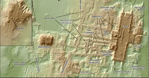
Scientists Have Made Hundreds of New Discoveries Using LiDAR
How could these discoveries change the way we view ourselves, and history
Hiya!
Until recently, the majority of our planet was a mystery—actually, that hasn’t changed. The majority of Earth is still a mystery. But, technology has finally advanced enough to provide two revolutionary tools allowing us to map the planet and make discoveries unlike never before.
The first is sonar, which I’ve written about before. It’s the technology experts use to map the ocean floor. The second is called Light Detection and Ranging (LiDAR), which helps experts map the land, including the landscape of dense jungles. I’m sure I’ve mentioned it before, but I can’t locate the article. Regardless, today I want to tell you about some pretty remarkable discoveries scientists have made over the last year or so using LiDAR.
LiDAR
LiDAR sends laser pulses and measures the time the light takes to return after it bounces off an object, then digitally creates 3-D maps of terrain and landscapes. It’s especially useful because it pierces dense vegetation that can inhibit our view. Experts use LiDAR from the air, like from a helicopter or airplane, though it can also be used on the ground to survey vegetation.
I first learned about LiDAR while watching an Albert Lin docu-series on National Geographic. Lin, and many other experts, have discovered that LiDAR reveals ancient ruins never before seen or even known of. There are a few where Lin, an engineer and scientist, uses LiDAR technology to map jungles in Central and South America, searching for lost Maya cities.
Many recent LiDAR discoveries surround the pre-Hispanic history of the Amazon and throughout Mexico. The Amazon, where untold ancient ruins remain hidden, is threatened by deforestation. When workers tear through the Amazon with bulldozers, the natural environment gets ripped apart, and any archaeological remains within reach are destroyed forever.
Now, LiDAR can show experts where ruins are so the areas can be protected before deforestation begins. Not to mention, it can take years to map a large archaeology site manually, whereas Lidar takes mere days to weeks to accomplish.
As mentioned, LiDAR pierces vegetation, providing a precise image of the landscape. Though from the air, LiDAR also reveals features of ruins out in the open, which remained hidden simply because of their large size.
There are a couple of downsides, though. To start with, the technology is still new, and while it holds immense promise, LiDAR is expensive and, of course, has numerous bureaucratic red tape before researchers can get approval to use it. Another issue is that many governments haven’t yet developed standard operating procedures, such as flight zoning over sites, how to label the data, or which LiDAR models to use.
Still, the technology itself is incredibly valuable. Think about it, in ten years, we could have all the landmass on the planet scanned. What might that information show us? What could we learn about our past or ourselves? How many remnants of our ancestors remain hidden? Well, if the last few years are any indication… there are a lot of them.
Surprise Discoveries
The fight, time, and patience pay off for archaeologists who manage to get funding and approval to use LiDAR.
An article by Artnet talks about an archaeological team at Caracol, an ancient Maya city in Belize, that spent four years trying to get approval to LiDAR scan an 80-mile-area around the city. In 2009, they finally got the okay, and to their amazement, the LiDAR scans showed the Maya city reached far deeper into the jungle than previously imagined.
Keep reading with a 7-day free trial
Subscribe to Curious Adventure to keep reading this post and get 7 days of free access to the full post archives.


